
Understanding Ksat: Soil Permeability vs. Septic Perc Tests
Learn what Saturated Hydraulic Conductivity (Ksat) measures in USDA soil surveys and understand why Ksat is not a septic percolation test.
Ksat measures how readily saturated soil transmits water downward under gravity. High Ksat values mean fast sand drainage; low values mean slow clay drainage.
Visualizing Saturated Hydraulic Flow & Perc Testing
This three-stage visual sequence illustrates saturated soil core permeability, pore size structure, and physical field percolation testing.
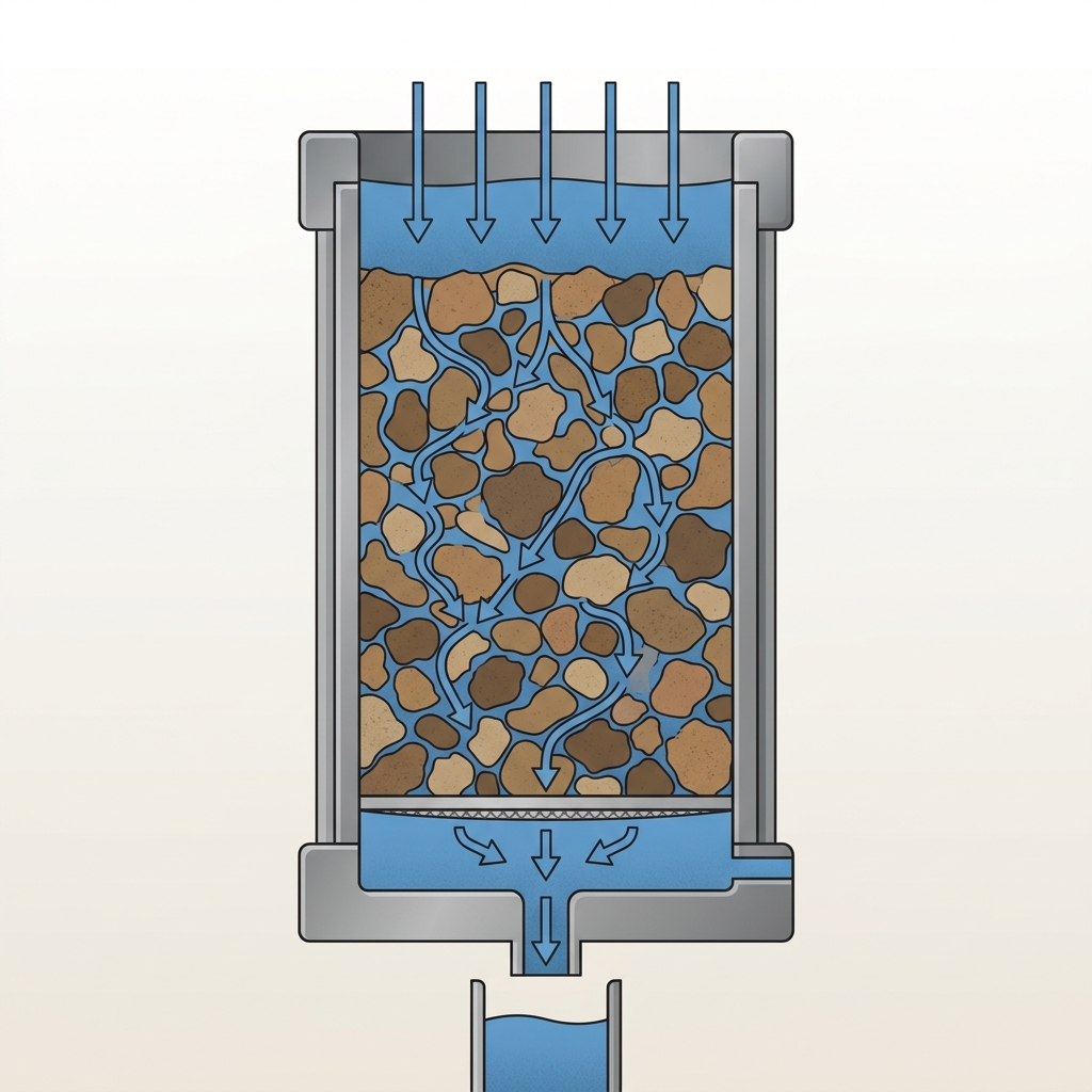
Vertical Water Movement Through Pore Spaces
Ksat describes the ease with which water moves downward through fully saturated soil pore spaces under a hydraulic gradient.
What to notice: Saturated water transmission occurs when soil pores are completely filled with water.

Coarse vs. Fine Pore Geometry
Coarse sand particles create wide connected pore channels with rapid water flow, while fine clay particles create narrow winding paths.
What to notice: Pore diameter and structure dictate hydraulic transmission rates.
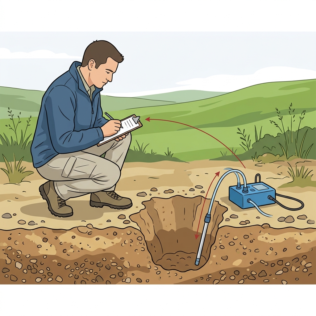
On-Site Engineering Evaluation
A physical field percolation test measures local water drop in an excavated test hole on a specific lot to evaluate septic system drain field suitability.
What to notice: Field perc testing is site-specific and serves a different purpose from survey estimates.
Key Takeaways
- Ksat measures saturated water flow rate through soil horizons under gravity.
- Ksat is a laboratory and survey estimate based on horizon traits.
- Ksat is NEVER a physical septic percolation test result.
What Ksat Measures
Saturated hydraulic conductivity describes water flow through soaked subsoil.
Ksat is a key physical property reported in USDA soil horizon records.
Ksat is a regional survey estimate. It does not replace an on-site physical percolation test or guarantee municipal septic system permitting approval.
Ksat vs. Septic Percolation Test Comparison
| Characteristic | USDA Ksat (Survey Value) | Septic Perc Test (On-Site Field Test) |
|---|---|---|
| Methodology | Survey values may reflect measurements, laboratory estimates, or representative interpretations | On-site physical water level drop measured in a field test hole |
| Primary Purpose | Regional soil classification & watershed modeling | Municipal septic drain field engineering evaluation |
| Spatial Scale | Mapped polygons covering multiple acres | Specific test hole location on an individual lot |
Official USDA Field Explanation: Ksat
Saturated Hydraulic Conductivity (Ksat)
1. What is it? (Plain English)
A measurement of how readily saturated soil transmits water downward under gravity.
Technical definition: The ease with which pores of a saturated soil transmit water under a hydraulic gradient.
2. How USDA Reports This Field
chorizon.ksat_rInterpretation Ranges & Rating Meanings
| Category / Level | Condition / Range | Physical Property Meaning |
|---|---|---|
| Very Low | < 0.42 µm/s | Water moves very slowly through saturated subsoil. |
| Low | 0.42 – 4.2 µm/s | Slow internal water movement through saturated subsoil. |
| Moderate | 4.2 – 42 µm/s | Moderate water movement through saturated loamy subsoil. |
| High | > 42 µm/s | Rapid water movement through saturated sandy subsoil. |
3. Why it matters for soil evaluation
Used by soil scientists to model subsoil water movement and vertical drainage rates.
4. What This Field Does NOT Prove (Limitations)
- Ksat is a laboratory and survey estimate, NEVER a physical on-site septic percolation test result.
- Does NOT prove an address will pass a municipal septic permit test.
- Ksat varies significantly across different horizon layers in the same soil profile.
USDA soil survey data provides broad mapped screening information across soil polygons. Field conditions on individual building lots can vary due to past grading, excavation, or micro-topography. Always consult a licensed geotechnical engineer or soil scientist for on-site parcel decisions.
How Ksat Appears in Subsurface Atlas Records
Subsurface Atlas extracts Ksat rates for every horizon layer.
Property Relevance
Screening context for regional subsoil permeability.
On-site perc testing or double-ring infiltrometer testing is required for engineering permits.
Survey Limitations & Notes
- Ksat rates reflect estimated saturated conditions across mapped horizon layers.
Common Myths vs. Reality
Local health codes consider slope, water tables, and setback distances alongside percolation rates.
Primary Sources & References
Want to see what soil layers exist under your property?
Enter any U.S. address into Subsurface Atlas to explore mapped USDA soil units, components, drainage classes, and horizon profiles.
Run Address Lookup →