
Flooding vs. Ponding in Soil Surveys: Frequency, Duration, and Depth
Understand the difference between overbank stream flooding and depression surface ponding in USDA soil survey records.
Flooding describes moving water flowing overbank from streams, while ponding describes standing water trapped in low surface depressions.
Visualizing Stream Flooding vs. Depression Ponding
This three-stage visual sequence illustrates overbank river flooding, enclosed depression ponding, and surface water duration.
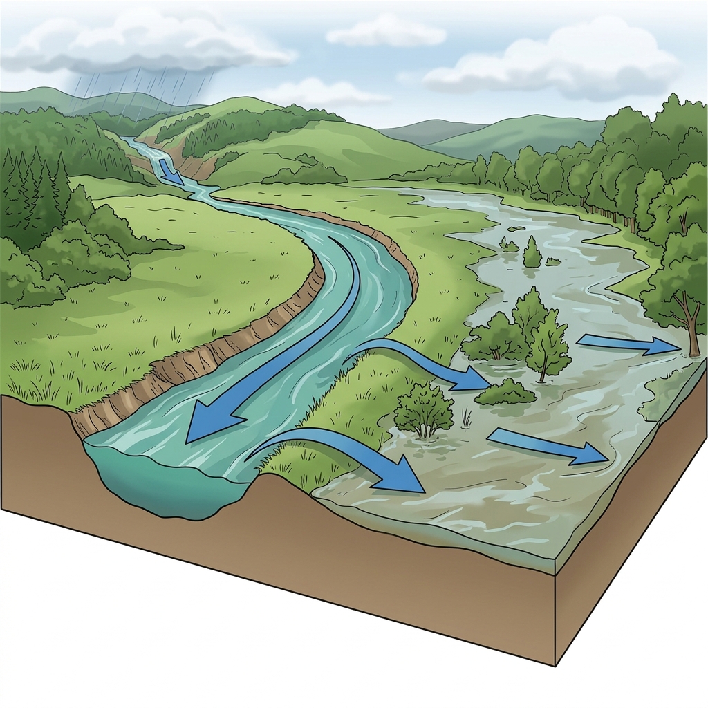
Water Arrives from External Stream Flow
Flooding occurs when water overtops river or stream banks and flows laterally across adjacent floodplain soils during high runoff events.
What to notice: Notice how floodwater originates from an external stream channel.
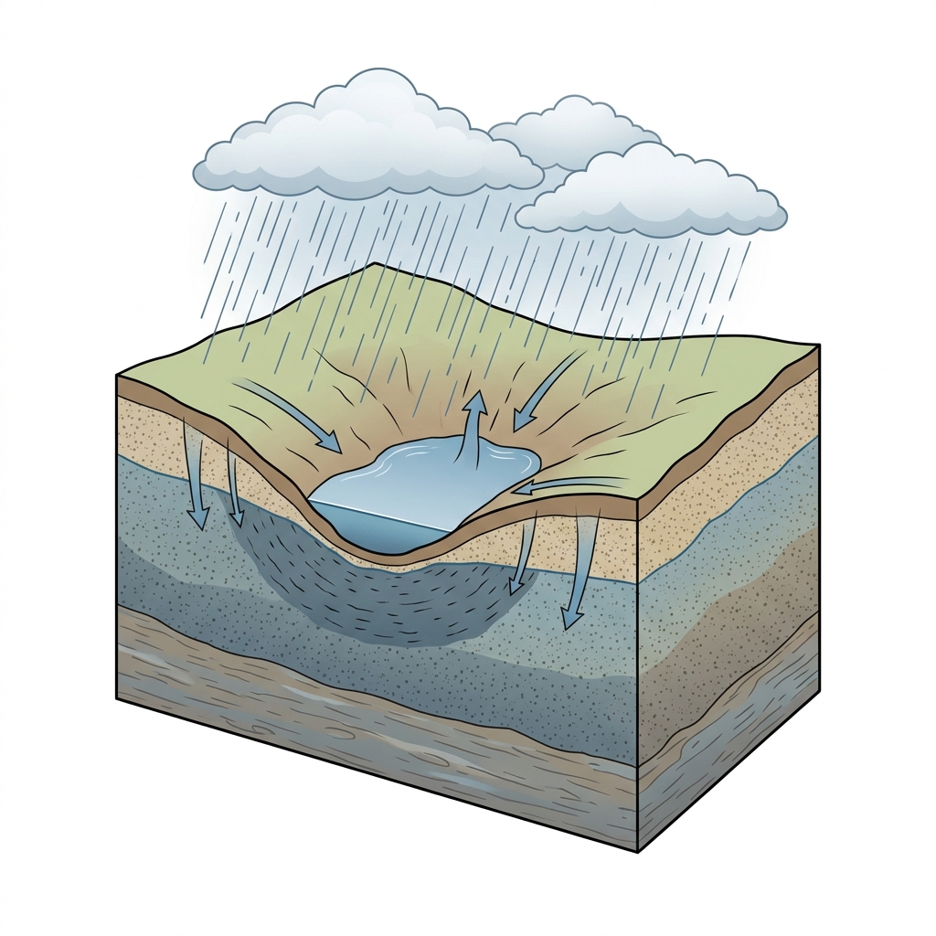
Standing Water Trapped in Depressions
Ponding occurs when surface precipitation collects in low enclosed landscape depressions where subsoil infiltration is slow.
What to notice: Ponded water is stagnant and enclosed rather than flowing laterally.
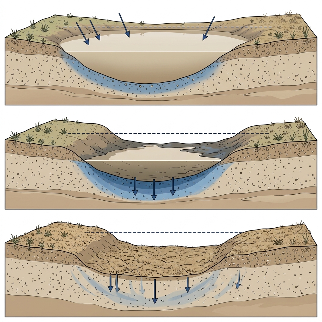
Temporal Wetness Progression
Soil survey records describe how often standing water occurs (frequency) and how long it remains (duration) before evaporating or infiltrating.
What to notice: Duration describes the time window water remains in the depression.
Key Takeaways
- Flooding comes from overflowing rivers or streams.
- Ponding comes from rain collecting in enclosed depressions.
- USDA flooding categories differ from official FEMA flood zone insurance maps.
Water Source Distinction
Soil surveys distinguish flowing floodwaters from standing ponded water.
Understanding whether surface wetness stems from stream overflow or local depression ponding is essential for site planning.
USDA soil survey flooding classes describe natural soil landscape wetness. They do not replace official FEMA Flood Insurance Rate Maps (FIRMs).
Flooding vs. Ponding Distinction Matrix
| Characteristic | Flooding (Overbank Flow) | Ponding (Surface Depressions) |
|---|---|---|
| Water Source | Overflowing rivers, streams, or tidal channels | Precipitation collecting in enclosed low spots |
| Water Movement | Flowing, moving surface water | Standing, stagnant surface water |
| Primary Cause | Upstream watershed runoff during storm events | Slow internal subsoil infiltration or depression micro-topography |
Official USDA Field Explanation: Flooding Frequency
Flooding Frequency & Duration
1. What is it? (Plain English)
The estimated chance and duration of overbank stream or river flooding across the ground.
Technical definition: The temporary covering of the soil surface by flowing water from overbank streams or rivers.
2. How USDA Reports This Field
comonth.flodfreqcl3. Why it matters for soil evaluation
Identifies low-lying floodplain areas susceptible to stream overflow during heavy rainfall events.
4. What This Field Does NOT Prove (Limitations)
- USDA soil survey flooding classes differ from official FEMA Flood Insurance Rate Maps (FIRMs).
- Does not substitute for a site-specific hydrological flood study or elevation survey.
Official USDA Field Explanation: Ponding Frequency
Ponding Frequency, Duration & Depth
1. What is it? (Plain English)
The estimated chance, duration, and depth of standing water accumulating in closed surface depressions.
Technical definition: The standing of water in a closed depression on the soil surface.
2. How USDA Reports This Field
comonth.pondfreqcl3. Why it matters for soil evaluation
Identifies landscape depressions where surface precipitation collects and drains away slowly.
4. What This Field Does NOT Prove (Limitations)
- Ponding refers to standing depression water, distinct from flowing river flooding.
- Artificial site grading, storm sewers, or localized micro-topography alter ponding behavior.
USDA soil survey data provides broad mapped screening information across soil polygons. Field conditions on individual building lots can vary due to past grading, excavation, or micro-topography. Always consult a licensed geotechnical engineer or soil scientist for on-site parcel decisions.
How Flooding & Ponding Appear in Subsurface Atlas Records
Subsurface Atlas extracts monthly flooding and ponding frequency classes.
Property Relevance
Screening context for surface water movement during major wet seasons.
On-site elevation surveys determine exact flood risk boundaries.
Survey Limitations & Notes
- USDA classes represent historical survey landscape estimates.
Common Myths vs. Reality
Heavy rainfall can still cause local lawn ponding if drainage channels are blocked.
Primary Sources & References
Want to see what soil layers exist under your property?
Enter any U.S. address into Subsurface Atlas to explore mapped USDA soil units, components, drainage classes, and horizon profiles.
Run Address Lookup →